Log in
All resources
Create a design
Tools
892 Free Images of Old Scale
bibliothèque nationale de france
maps of spain by tomas lopez
chorographia britanniae (1741-1742)
maps by willem and johannes blaeu
maps from university of amsterdam special collections
copperplate print
special collections of the university of amsterdam
nature
atlas der neederlanden
guillaume sanson
1640s maps of hesse
old maps of nassau
aus dem alten frankfurt. radirungen von bertha bagge.
haus zur goldenen waage
old maps of auvergne
1660s maps of france
maps by thomas kitchin
1781 maps of europe
maps by willem and johannes blaeu
william camden
maps in the library of congress
1758 maps of cuba
maps in the library of congress
1875 maps of california
cartoons by joseph keppler
puck, 1886
cartoons by joseph keppler
puck, 1886
vigo in the 18th century
1702 maps of spain
atlas der neederlanden deel ii: holland 1. zuid-holland
maps from university of amsterdam special collections
old maps of piedmont
maps by gerard valck
old maps of the new kingdom of granada
maps by willem and johannes blaeu
maps of spain by tomas lopez
1765 maps of spain
maps of spain by tomas lopez
1765 maps of spain
maps of spain by tomas lopez
old maps of navarre
maps of spain by tomas lopez
old maps of navarre
maps of spain by tomas lopez
1766 maps of spain
maps of spain by tomas lopez
old maps of navarre
maps of spain by tomas lopez
1765 maps of spain
maps of spain by tomas lopez
old maps of navarre
maps of spain by tomas lopez
1765 maps of spain
maps by willem and johannes blaeu
old maps of quercy
building
nature
allegorical paintings by laurent de la hyre
classicism
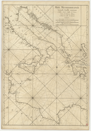
carte de la mer méditerranée en trois feuilles (dheulland et al.)
old maps of the central mediterranean
17th-century maps of cambridgeshire
old county maps of cambridgeshire
old maps of milan
antoine aveline
old maps of lazio
henry le roy
old maps of bourbonnais
1660s maps of france
17th-century maps of savoie
old maps of savoie
landais & oberthur
maps from gallica
la rioja (spain) in the 18th century
old maps of la rioja (spain)
old maps of the region of murcia
maps of spain by tomas lopez
old maps of asturias
1777 maps of spain
old maps of asturias
1777 maps of spain
old maps of asturias
1777 maps of spain
gustav freytag (cartographer)
old maps of karlovy vary
old maps of the balearic islands
maps of spain by tomas lopez
maps of spain by tomas lopez
1768 maps of spain
old maps of norway
guillaume sanson
maps by willem and johannes blaeu
old maps of quercy
old maps of norway
guillaume sanson
nature
grass
chorographia britanniae (1741-1742)
18th-century maps of essex
chorographia britanniae (1741-1742)
18th-century maps of wiltshire
old maps of amsterdam
hendrik de leth
maps by willem and johannes blaeu
old maps of berry
maps of cities in venezuela
maps by juan lopez
magazine fort, dublin
maps by john rocque
maps from university of amsterdam special collections
atlas der neederlanden
portrait paintings by george desmarées (house of wittelsbach)
rococo
1762 maps of north america
maps by tomas lopez
historical
history
18th-century maps of edinburgh-shire
maps of scotland by herman moll
baptista van doetecum
jacques surhon
maps of spain by tomas lopez
1778 maps of spain
maps of spain by tomas lopez
1778 maps of spain
historical
history
chorographia britanniae (1741-1742)
18th-century maps of sussex
16th-century maps of crete
old maps of candia
old maps of nova belgica et anglia nova
maps by willem and johannes blaeu
old maps of norway
guillaume sanson
maps by willem and johannes blaeu
1640s maps of belgium
magnifying glass
law
1640s maps of greece
marco boschini
maps from university of amsterdam special collections
atlas der neederlanden
maps by abraham ortelius
pieter van der keere
maps from university of amsterdam special collections
atlas der neederlanden
maps from university of amsterdam special collections
atlas der neederlanden
maps from university of amsterdam special collections
atlas der neederlanden
maps from university of amsterdam special collections
atlas der neederlanden
maps from university of amsterdam special collections
atlas der neederlanden
animals
fish
chorographia britanniae (1741-1742)
18th-century maps of cornwall
chorographia britanniae (1741-1742)
18th-century maps of kent
historical
history
carte de la mer méditerranée en trois feuilles (dheulland et al.)
old maps of the central mediterranean
carte de la mer méditerranée en trois feuilles (dheulland et al.)
old maps of the central mediterranean
chorographia britanniae (1741-1742)
18th-century maps of monmouthshire
chorographia britanniae (1741-1742)
18th-century maps of middlesex
chorographia britanniae (1741-1742)
18th-century maps of westmorland
18th-century maps of nottinghamshire
chorographia britanniae (1741-1742)
animals
fish
animals
fish
animals
fish
18th-century maps of huntingdonshire
chorographia britanniae (1741-1742)
chorographia britanniae (1741-1742)
18th-century maps of cumberland
chorographia britanniae (1741-1742)
18th-century maps of cambridgeshire
chorographia britanniae (1741-1742)
18th-century maps of lancashire
chorographia britanniae (1741-1742)
18th-century maps of northumberland
old maps of haarlem
haarlemmerhout
bibliothèque nationale de france
guillaume sanson
maps by willem and johannes blaeu
old maps of westmorland
maps in the library of congress
old maps of new jersey
animals
fish
animals
fish
bibliothèque nationale de france
guillaume sanson
bibliothèque nationale de france
guillaume sanson
schoten, netherlands
heerlijkheid zaanen
601 - 700 of 892
Next page
/ 9


![Lodge atop the roof of the Goldene Waage [Golden Scales] (Alter Markt [Old Market] No. 5.), Bertha Bagge, 1890](https://cdn.creazilla.com/illustrations/10000383670/lodge-atop-the-roof-of-the-goldene-waage-golden-scales-alter-markt-old-market-no-5-bertha-bagge-1890-sm.webp)


![Map of the Ring of Putten, Gilliam van der Gouwen, [1701]](https://cdn.creazilla.com/illustrations/10001174499/map-of-the-ring-of-putten-gilliam-van-der-gouwen-1701-md.jpg)

![TERRA FIRMA et NOVUM REGNUM GRANATENSE et POPAYAN., [1630-1670]](https://cdn.creazilla.com/illustrations/10001462419/terra-firma-et-novum-regnum-granatense-et-popayan-1630-1670-md.jpg)


![Sabinorum et Marsorum agri descriptio. 11; Typus utriusque Latii [...]. 8 / auctore Philippo Cluverio; H. Le Roy fecit, 1624](https://cdn.creazilla.com/illustrations/10001535937/sabinorum-et-marsorum-agri-descriptio-11-typus-utriusque-latii-8-auctore-philippo-cluverio-h-le-roy-fecit-1624-sm.webp)


![Topographic map of the south-western slope of Menez-haut / surveyed and drawn up [...] by AM Kamelin, 1849](https://cdn.creazilla.com/illustrations/10001387383/topographic-map-of-the-south-western-slope-of-menez-haut-surveyed-and-drawn-up-by-am-kamelin-1849-sm.webp)


![Map of Ceylon - European Colonial Establishments, Jakob van der Schley, [1750]](https://cdn.creazilla.com/illustrations/10000562848/map-of-ceylon-european-colonial-establishments-jakob-van-der-schley-1750-sm.webp)


![Map of the craftsmanship of the Old and New Streuyt / A. Steyaart invenit; I. Stemmer's sculpsit; I. Shutters fecit cum aqua forti, Romeyn de Hooghe, [1701]](https://cdn.creazilla.com/illustrations/10000536041/map-of-the-craftsmanship-of-the-old-and-new-streuyt-a-steyaart-invenit-i-stemmers-sculpsit-i-shutters-fecit-cum-aqua-forti-romeyn-de-hooghe-1701-md.jpg)

![T Hoogh-Heemraetschap vande Uytwaterende Sluysen in Kennemerlant and West Frieslant / [Johannes Douw], Isaak Tirion, [1756]](https://cdn.creazilla.com/illustrations/10000560278/t-hoogh-heemraetschap-vande-uytwaterende-sluysen-in-kennemerlant-and-west-frieslant-johannes-douw-isaak-tirion-1756-md.jpg)
![T Hoogh-Heemraetschap vande Uytwaterende Sluysen in Kennemerlant and West Frieslant / [Johannes Douw], Isaak Tirion, [1756]](https://cdn.creazilla.com/illustrations/10000976652/t-hoogh-heemraetschap-vande-uytwaterende-sluysen-in-kennemerlant-and-west-frieslant-johannes-douw-isaak-tirion-1756-md.jpg)
![Special map of a part of Dutch Brabant, Guelders and Cleves or the surroundings of Grave, Ravestein, Helmont, Nijmegen, Fort de Schenk, Cleves, Gennip, Emmerick &c. / I. Condet f. 1748, Johannes Condet, [1748]](https://cdn.creazilla.com/illustrations/10000963180/special-map-of-a-part-of-dutch-brabant-guelders-and-cleves-or-the-surroundings-of-grave-ravestein-helmont-nijmegen-fort-de-schenk-cleves-gennip-emmerick-c-i-condet-f-1748-johannes-condet-1748-md.jpg)
![T Hoogh-Heemraetschap vande Uytwaterende Sluysen in Kennemerlant and West Frieslant / [Johannes Douw], Isaak Tirion, [1756]](https://cdn.creazilla.com/illustrations/10001440533/t-hoogh-heemraetschap-vande-uytwaterende-sluysen-in-kennemerlant-and-west-frieslant-johannes-douw-isaak-tirion-1756-md.jpg)
![T Hoogh-Heemraetschap vande Uytwaterende Sluysen in Kennemerlant and West Frieslant / [Johannes Douw], Isaak Tirion, [1756]](https://cdn.creazilla.com/illustrations/10000841147/t-hoogh-heemraetschap-vande-uytwaterende-sluysen-in-kennemerlant-and-west-frieslant-johannes-douw-isaak-tirion-1756-md.jpg)